 |
Database Primitives for Spatial Data Mining
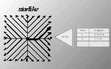
We have developed a set of database primitives for mining in spatial databases
which are sufficient to express most of the algorithms for spatial data
mining and which can be efficiently supported by a DBMS. We believe that
the use of these database primitives will enable the integration of spatial
data mining with existing DBMS’s and will speed-up the development of new
spatial data mining algorithms. The database primitives are based
on the concepts of neighborhood graphs and neighborhood paths. |
 |
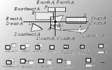
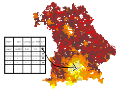
Efficient DBMS Support
Effective filters allow to restrict the search to such neighborhood paths
“leading away” from a starting object. Neighborhood indices materialize
certain neighborhood graphs to support efficient processing of the database
primitives by a DBMS. The database primitives have been implemented on
top of the DBMS Illustra and are being ported to Informix Universal
Server. |
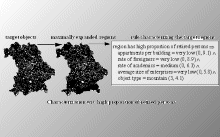 |
Algorithms for Spatial Data Mining
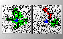
New algorithms for spatial characterization and spatial trend analysis
were developed. For spatial characterization it is important that class
membership of a database object is not only determined by its non-spatial
attributes but also by the attributes of objects in its neighborhood. In
spatial trend analysis, patterns of change of some non-spatial attributes
in the neighborhood of a database object are determined. |

 Spatial Data Mining